

GIS Resources at The DHS Program
By Clara Burgert
The first DHS survey to use geographic location data was the 1996 Benin DHS. At that time, Geographic Information Systems (GIS) Day didn’t even exist (it was first started in 1999)! But over the years, we’ve collected location data in more and more surveys—over 120 to date. Our offerings in terms of GIS tools for understanding the data we’ve collected have also become richer. These data serve the important role of helping us to understand the linkage between health behavior or outcomes and physical location.
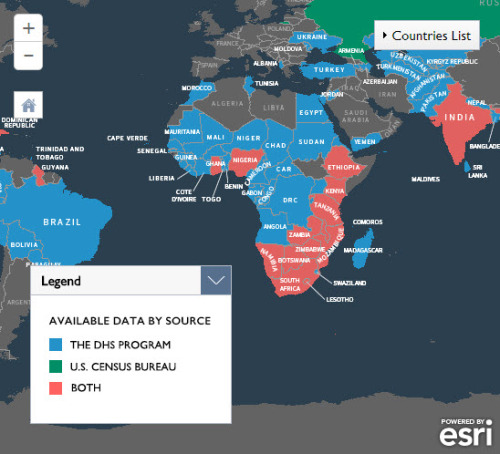
One of the key GIS tools that The DHS Program has created is the Spatial Data Repository (SDR). The Spatial Data Repository provides geographically-linked health and demographic data from The DHS Program and the U.S. Census Bureau for mapping in a GIS. The SDR has gone through many iterations before it arrived at its present design. Originally, the site was just a host for users to download .zip packages of information. When we launched the current SDR last year, it had been completely redesigned to include several new functionalities, including the Boundaries page, which allows users to take a look at ways in which boundaries have changed over time in DHS surveys. The SDR is one of the first USAID-funded sites that is fully open data, that is, any user can go to the site and download information for free, without having to go through a process of registration or requesting.
As of September this year, the SDR has added even more resources. The boundary page has a comparison page, and we’ve added more maps and search functions to the SDR Gallery, where users can peruse maps that were created from the SDR data. Users can submit their own maps, and they may also be featured on the site.
We’ve also created several video tutorials that explain more about how to use GIS resources (and three SDR-specific videos) at DHS.
Be it today for GIS Day or any day of the year, The DHS Program GIS resources are available to assist you in visualizing and analyzing DHS data.
Très bien Clara et très intéressant. J’espère avoir le temps d’explorer les liens un de ces jours.