

From National to Local: A New Way to Leverage DHS Data
In DHS survey final reports, data are presented on a national or first-level administrative sub-national level. However, this is usually not the level at which program planning and decision making are truly happening. To support more decentralized decision making at lower administrative levels, data need to be presented on a more disaggregated level.
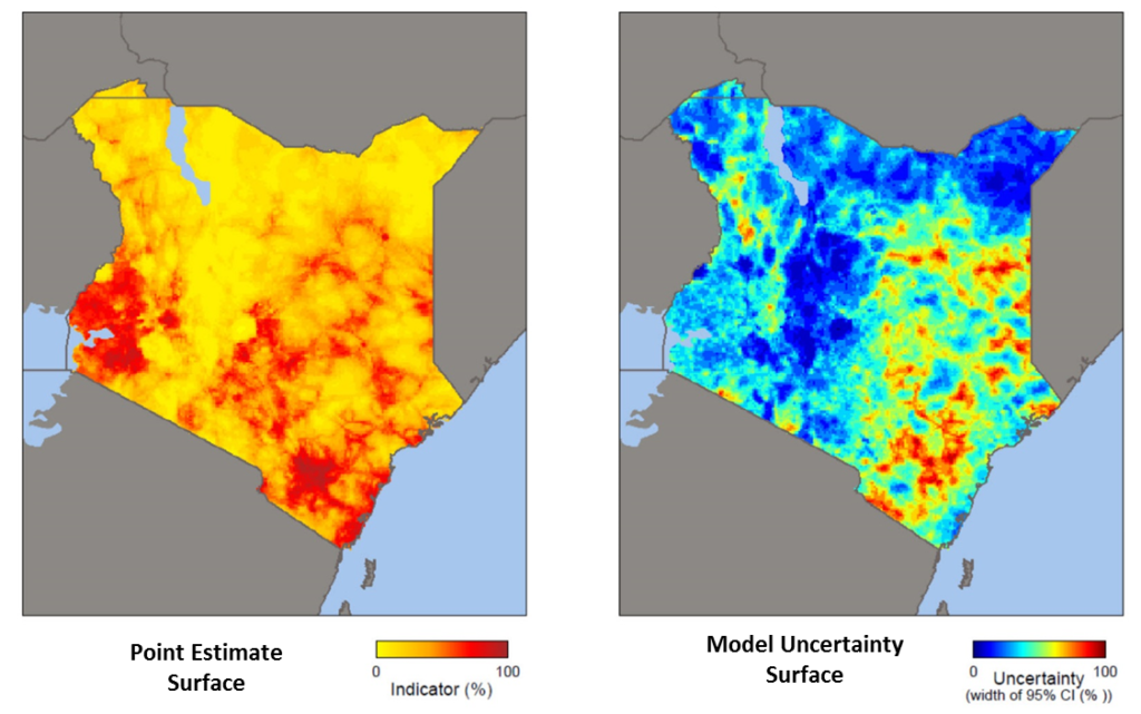
The DHS Program is producing a standard set of spatially modeled map surfaces for each population-based survey for a select list of indicators that provide smaller area estimates of data. Geostatistics are used to predict (interpolate) the indicator value for unsampled areas based on data from sampled data locations. DHS creates standardized modeled map surfaces using DHS survey data along with global covariate datasets. Currently, sets of standard surfaces are available for 16 surveys. Spatial data packages and stand-alone maps are available for download through The DHS Program’s Spatial Data Repository.
How can modeled map surfaces be used?
These new spatially modeled surfaces can help in several ways to improve decision making for many development sectors that include health, population, nutrition, and water and sanitation programs on multiple levels. Users can combine the maps with other resources to support:
- Monitoring and evaluation: analysis and evaluation of past initiatives (impact analysis) or understanding existing situations
- Program planning: future planning of appropriate programs and policies
Data in the modeled surfaces can be used to evaluate past programs or to better understand existing situations. Such evaluations can help to understand deviations from the norm, attribute cause, or to contribute to impact evaluations, which analyze what would have happened to the population of an area if a program had not been implemented.
Program managers can also use modeled surfaces to plan, target, and develop interventions and programs that aim to improve situations in targeted geographic areas. Interventions can be targeted more precisely, saving money, time, and human resources in the search for the most effective outcomes.
The matrix below shows potential approaches for monitoring and evaluating past and planning future programs using modeled surfaces.
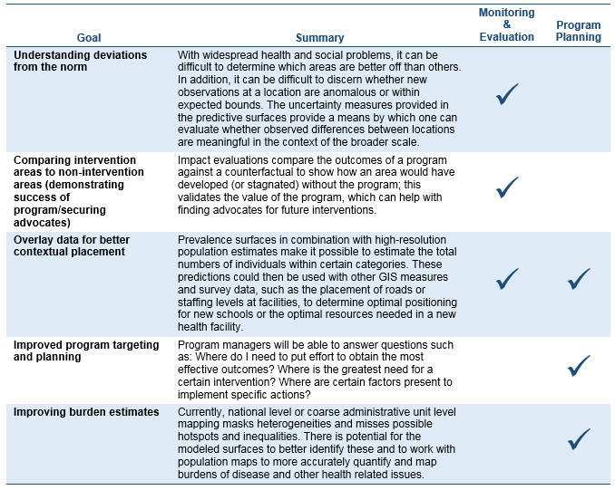
This matrix is by no means comprehensive, and it is expected that map users will come up with many more potential uses after analyzing their particular situation and maps for their country.
To read more, please see the Spatial Analysis Report 14, “Guidance for Use of The DHS Program Modeled Map Surfaces.” The report delivers more in-depth information on what modeled surfaces The DHS Program is creating, as well as an explanation of their creation process. In addition, the report provides guidance on limitations and assumptions.
The DHS Program is looking forward to seeing how groups will use this new data product to enhance their activities. There is enormous potential for innovative uses of these modeled surfaces beyond those discussed in the report. Users are encouraged to submit ideas and case studies to The DHS Program (spatialdata@dhsprogram.com) as only a large community of users who share their experiences will fully expose the maps’ potential.
 Aileen Marshall is the Knowledge Management/Monitoring & Evaluation Specialist at The DHS Program. She is responsible for planning, development, implementation and evaluation of the KM strategy, KM activities as well as the project-wide SharePoint site. Additionally, she is involved in measuring and evaluating capacity strengthening activities at DHS and works closely with all teams to ensure knowledge at DHS is captured, stored and shared efficiently among staff. Aileen holds an MA in English Linguistics from the Westfaelische Wilhelms-University in Muenster, Germany, and an MLIS from the University of South Carolina.
 Trinadh Dontamsetti is the Health Geographic Analyst for The DHS Program. He contributes to geospatial analysis, mapmaking, and geographic data processing activities. His research interests include geospatial interpolation, tuberculosis, and vector arthropod-borne diseases.
 Clara R. Burgert is the GIS Coordinator for The DHS Program. She oversees all geographic data, mapping, and geospatial analysis activities at The DHS Program. Additionally, she facilitates workshops in partner countries on using maps for better decision making using open source GIS software.