Linking DHS Data with Health Facility Data: Opportunities and Challenges
For 30 years, The DHS Program has asked women hundreds of questions about their utilization of various health care services, including family planning, antenatal and delivery care, vaccination and treatment of sick children, malaria treatment, and HIV prevention and treatment. In 1999, The DHS Program started collecting facility-level data through the Service Provision Assessment (SPA) survey. The SPA interviews providers and clients, takes stock of facility supplies and equipment, and observes provider-client consultations.
Many people hoped that the two datasets would be easy to link for a deeper understanding of how people access services, the quality of services, and the association between access to services and health outcomes in a given country. And because most recent DHS and SPA surveys are geo-coded (DHS since 2000 and SPA since 2009), that is, clusters and facilities are identified with their latitude and longitude, linking the data through a geographic information system should be easy, right?
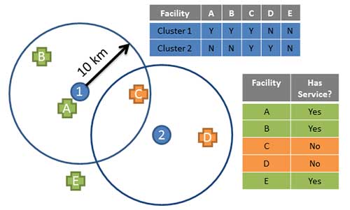
Several studies have looked at using geospatial analysis to link DHS and SPA data to answer these larger questions about access to and utilization of health care services. There are several challenges to this type of linkage. A major concern is sampling: the DHS and SPA surveys have different sampling frames and are rarely conducted in the same year. Most SPAs are samples of the health care facilities in the country, not a census. Many individuals surveyed in a DHS likely visit some of the health facilities that were not selected for the SPA. So just because a woman’s cluster is closest to a certain facility included in the SPA does not mean that that is the facility the woman visits.
 In addition, to protect the identity of respondents, the GPS locations of DHS cluster points are geo-masked. In densely populated areas, this means that clusters may be moved away from their closest health facilities, making linkage based on geographic location less accurate. There’s also a practical concern: the DHS does not ask where individuals receive health care but rather only the type of facility where they sought care. While some people probably use their closest health facility, this is not always the case. People may choose health facilities based on quality, specialty, cost, or anonymity, not just proximity.
 Despite the challenges there have been several successful analyses linking DHS and SPA data, and program managers and researchers continue to explore the best use cases for DHS-SPA linkage. This will be the topic of our upcoming DHS webinar on July 28th, “Considerations when Linking DHS Household Data to Data on Health Facilities and Infrastructure.” Clara Burgert, The DHS Program’s GIS Coordinator and author of the recently released Spatial Analysis Report “Linking DHS Household and SPA Facility Surveys: Data Considerations and Geospatial Methods” will be making a presentation on the DHS-SPA linkage opportunities and challenges. Interested participants can register for the webinar here, and are encouraged to read SAR10 and post discussion questions for Clara and her co-authors on The DHS Program User Forum here.
Update: This webinar event has ended. Please visit this feed on The DHS Program User Forum for the presentation, discussion, and additional resources.

